
Some of the fieldwork projects that SOAG has recently completed, and a selection of older projects, are outlined here. These include:
- Wyfold Grange
- Goring Heath Landscape study
- Digberry Lane, Park Corner
- High Wood Romano-British Temple
- Kelmscott Manor Community Archaeology Project
- Exlade Street Landscape Archeological Survey
- Blewbury Quaker Field
- The lost church of Bix Gibwyn
Wyfold Grange

This project, running from 2021-2023 was aimed at unravelling the origins and development of Wyfold Grange in South Oxfordshire.
The goals were:
- to try to establish, by excavation, the nature and extent of the earthwork enclosure and in particular any evidence for dating.
- to carry out geophysical surveys in the open spaces of the site. A particular aim was to see if the medieval manor house could be located.
- to understand more about the pond and its potential water sources by core sampling (augering) and hydrological research.
- to establish archaeological walks around the site in order to bring information about the history of the area to members of SOAG and the wider public.
The project is now completed and the results are published in a special edition of SOAG’s journal: SOAG Bulletin No. 75. (click the link to access the PDF version).
The component reports are also separately available:
Excavations of the Earthwork at Wyfold Grange, Oxfordshire
Landscape Archaeology At Wyfold, Oxfordshire
Post-Medieval Archaeology At Wyfold Grange, Oxfordshire
Wyfold Grange, Oxfordshire An Archaeological Walk
Goring Heath Landscape Study

The SOAG Goring Heath Landscape Study began in 2020 in response to the Chilterns Conservation Board’s (National Lottery Heritage Fund funded) ‘Beacons of the Past’ (BotP) Project.
The BotP project in 2019 completed a high-resolution LiDAR survey of the Cilterns AONB, and had as one of it purposes to kick start Citizen Science projects, using the LiDAR maps as the starting point and with initial support from the BotP project. Click here for more details of the SOAG Study, which has now moved into its documentary phase.
Digberrry Lane, Park Corner

The image (left) shows a DEFRA LiDAR image of a well known rectangular enclosure at Digberry Lane, Park Corner near Nettlebed. There is debate as to the age of the enclosure and in late 2023, SOAG carried out a geophysical survey in areas in the centre of the main enclosure and in the centre and northern edge of the secondary enclosure.
Resistivity plots demonstrated some tantalising features in the centre of the main enclosure, but unfortunately subsequent test pits did not uncover any archaeological features and and no dating evidence. The site was subject to a recent, but unsuccessful, application for scheduling by Historic England (Case number 1488211), and more detail can also be found in that case report (04/03/2024).
Subsequently, due to a change of ownership, SOAG was able to gain access to the north west corner of the largely ploughed out secondary enclosure, which might possibly be the remains of a Roman marching camp. Following a geophysical survey, we were able to participate in an excavation of some areas of the enclosure. For more information on the 2025 excavations click here.
Roman temple at High Wood, Harpsden
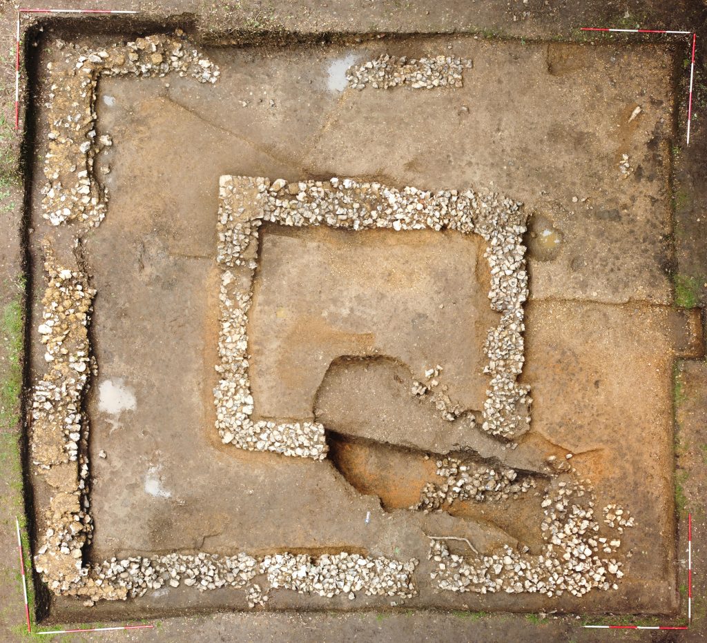
Over seven seasons of excavation from 2015-2021, SOAG investigated the partial remains of a Romano-Celtic temple complex with the inner temple chamber or cella surrounded by a walkway referred to as an ambulatory.
These remains are set within a rectangular temenos enclosure that encompasses a range of rooms to the north. These buildings appear to have suffered a catastrophic collapse in antiquity.
The complex overlies evidence of Late Iron Age/Early Romano-British exploitation of the site and there is evidence of a possible Beaker period burial in the locality. For more information click here.
A full report, with specialist finds reports, is available as SOAG Bulletin Number 74
Kelmscott Community Archaeological Project
Kelmscott Manor, a 16th century grade 1 listed manor house, is near Faringdon on the upper reaches of the River Thames, (about 5 miles from SOAG’s Smokedown project). It is owned by the Society of Antiquaries, and was the country retreat of the designer William Morris from 1871 until his death in 1896.

As part of the Kelmscott Community Archaeological Research Programme SOAG was invited to conduct geophysical surveys over some of the Kelmscott Manor land, under the auspices of a professional archaeology company, Cotswold Archaeology.
SOAG undertook both magnetometry and resisitivity surveys, on the basis of which Cotswold Archaeology organised digs undertaken by community volunteers, to which SOAG members were invited.
Exlade Street Landscape Archaeology
In the 1980s SOAG’s founder, Cynthia Graham Kerr, researched the buildings and landscape of Exlade Street, near Woodcote.

SOAG and The Oxfordshire Woodland Group took up where Cynthia left off, leading a new multipart project, which includes: searching for lost buildings; understanding how local timber buildings were constructed; and studying how the local woodlands were exploited for these purposes, in particular how extant sawpits were used to convert timbers.
An exploratory dig of some features on the land took place as part of SOAG’s Goring Heath Study. See the Exlade Street project page for further details.
Blewbury Quaker Field

A short series of non-intrusive archaeological surveys was conducted by SOAG on a field being acquired for plantation of a new wood. The aim of the surveys was to see if any trace of the Quaker Meeting House that is marked on an 1805 map (shown left), or any burials associated with it, could be found.
Part of the field was subject to geophysical surveying, combined with fieldwalking and metal detecting. A scattering of masonry on the field surface is evidence for a building in the expected location of the Meeting House. No new evidence of burials was found but metal detecting found evidence of human activity at the site from Roman times,and one find has potential connection to the Quaker movement. Click here to download a report.
Lost Church of Bix Gibwyn

Operating on behalf of the Victoria County History Oxfordshire survey, SOAG investigated the medieval manorial centres at Bix Gibwyn and Bix Brand, in particular looking for evidence of the lost parish church of Bix Gibwyn. See our Bix Gibwyn project pages for more information.