With the generous permission of the landowners, this multi-year project is the archaeological investigation of a Late Iron Age enclosure overlain by a substantial Romano-British villa (and surrounded by a complex system of enclosures, fields and trackways) in the Upper Thames Valley.
The site, at Smokedown Farm in West Oxfordshire, was initially identified following the discovery of potsherds and ceramic building material (CBM) distributed across the centre of the field and a spread of roman coins found by metal detectorists. The project started with some very limited geophysical surveying in 2020 and the first trenches were opened in summer 2021. SOAG is usually able to excavate at Smokedown for a period of up to seven weeks in the summer.
This page gives a summary of the explorations and surveys undertaken in each of the years so far.
Further annual summary reports are available (to members only) on the Smokedown Project Reports and Documents page.
The full results of the excavations, together with analysis of the finds, are planned to be published in due course in the SOAG Bulletin.
2020

In the first visit to the site in 2020 we were only able to undertake limited magnetometry surveying. The surveying in the centre of the field did reveal an almost rectangular double ditch enclosure (see figure left), with a very strong magnetic feature to the south west of the enclosure. This feature had not previously been identified in historic monument records.
2021
The 2021 Fieldwork comprised two aims:
- first, further geophysical work, including re-surveying the enclosure area with magnetometry at greater resolution and extending the area of survey of the wider field; and
- second, exploratory excavation of the northern perimeter of the enclosure area by two trial trenches, with a view to establishing its nature and the depth, extent and condition of any archaeological remains.
Magnetometry

The enhanced image of the enclosure area (figure left) shows a range of ditches, gullies and other potential features indicative of multi-period activity and reorganisation and which may potentially belong to Iron Age and Roman phases (although earlier or later features cannot be ruled out). The inner and outer ditches marking the perimeter may be contemporary or, more likely, result from reorganisation.
Within the enclosure itself, the image reveals parts of four possible ring gullies (possibly indications of roundhouses or ancillary buildings/enclosures) and a rectangular feature at the western end (which coincides with the area where the surface scatter of pottery and building materials was most prevalent).
Excavation
The figure above also shows the position of trenches 1 and 2, and the final overheads with context labels are below. Topsoil and agricultural subsoil above the archaeology was found to be 40-50 cm deep, so that excavations had to be somewhat selective.

In trench 1 (left) work was concentrated on taking a section of the enclosure ditch and excavating the wall on the southern (inner) side of the ditch and a limestone/mortar spread on the northern (outer) side of the ditch.
The perimeter ditch was found to be nearly four metres wide from lip to lip and is believed to be Late Iron Age in origin – the lower fill contained pottery sherds from the first half of the 1st Century AD, as well as livestock bones and (indicating standing water and therefore accumulation during use) freshwater snails. The upper ditch fill, which appears to be back-fill, contained pottery from a wide range of dates from the 2nd to the 4th Centuries AD. The wall to the south is Roman in construction. Sherds of pottery found immediately beneath the wall date from the late 1st or the earlier part of the 2nd Century AD, providing an indication as to possible date of the wall itself. The wall is therefore later than the ditch and therefore represents a reorganisation of the enclosure. The function of the limestone/mortar spread overlapping the outer northern edge of the ditch is uncertain at this stage – possibly a platform forming the base of a structure.

Trench 2 (left) revealed two uniform gullies, which the magnetometry indicates meet to form one corner of a rectangular enclosure. Pottery finds indicated that the ditch fills date from the 2nd Century AD onwards.
- An annual Summary Report on the fieldwork undertaken at Smokedown in 2021 is available to members on the Smokedown Project Reports and Documents page.
- A fuller Interim Report on the background to and fieldwork undertaken at Smokedown in 2020 and 2021 is also available to members on the Smokedown Project Reports and Documents page
2022
The principal objective of the further fieldwork in 2022 was to locate buildings and other features associated with the Romano-British occupation of the site.
Resistivity survey
A resistivity survey of the western end of the enclosure was carried out and the resulting image (below) clearly showed the outline of a large villa, with a central section comprising double corridors/verandas with several rooms off, together with a northern wing formed by a large, apparently aisled, building. It is also likely that there was a southern wing (possibly the location of the bathhouse), but this has yet to be confirmed by further excavation. A further building is shown lying across the southern inner perimeter ditch.

Excavation
In tandem with the resistivity survey, a number trenches were excavated at the western end of the enclosure.
Trench 3 (right) revealed the lowest courses of the two westernmost villa walls. The inner of these walls was constructed over two earlier pits which, from initial examination of the pottery within the fills, are likely to date from the Late Iron Age in line with the enclosure ditch. In the western part of the trench there was a spread of roof tile and other debris, suggestive of roof fall.

Beneath the debris was a limestone/mortar surface laid over a drainage gully. The circular feature in the centre of the trench was not a post-hole – it contained signs of burning, but no remnants of a post. Its purpose is currently unclear. The same is the case for the two groups of loose stones, principally red sandstone, on either side of the trench.

Trench 4 (left) revealed the eastern external wall of the villa. Next to it was a spread of highly magnetic baked clay, limestone and charcoal, possibly the lining of an oven constructed against the villa wall.
To the east was a second wall, seemingly part of a separate building suggested by the resistivity image to have been located to the east of the central core of the villa. Inside this wall was a heavily mortared floor surface about 10cm thick, cut by later activity
Trench 5 was a trial trench to determine whether the substantial anomaly shown by the magnetometry image in the south-west corner of the enclosure is a feature associated with Roman period occupation. The trench revealed the edge of a pit sloping down towards the centre of the feature and filled by a highly magnetic mixture of baked clay and sand together with ash, charcoal and baked tile. It also contained redeposited painted plaster but no structural remains were found. It is thought that this feature may be a clamp kiln – a simple form of kiln where the material to be baked is piled up in a pit and surrounded by combustible material which is then ignited. Variations in the tone of the fill suggest that it was fired on several occasions and there is evidence to suggest that it may have been used to make the flue-tiles commonly found amongst the site surface scatter and trench finds.
Trench 6 uncovered the western end of the building shown by the resistivity image to have been constructed astride the southern inner perimeter ditch. The ditch (about 3.5m wide consistent with the northern inner perimeter ditch excavated in 2021 in Trench 1) was filled with redeposited clay and other material.
- An annual Summary Report on the fieldwork undertaken at Smokedown in 2022 is available to members on the Smokedown Project Reports and Documents page.
2023
Magnetometry survey
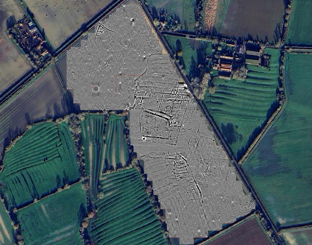
The 2023 fieldwork extended the magnetometry survey of the wider field to include the area to the north (see right). This revealed an interesting array of further anomalies indicating enclosure boundaries and other features. The northern extent of the settlement appears to have been delineated by a watercourse which previously crossed the field. The image also shows shadows of the later ridge & furrow, some of which seem to be aligned with enclosure boundaries, suggesting that lumps and bumps remaining from the Iron Age / Romano-British settlements were still visible long after the end of the Roman period. The further magnetometry and crop marks underline that that our immediate area of interest in the enclosure area is part of a much wider settlement.

Excavation
Iin 2023 trenches were opened to explore the northern part of the villa site that had been revealed by the resistivity survey. Two of the trenches – 9 and 10 – were positioned with a view to investigating the sequence and relationship of the villa building, the adjacent aisled buiding and the single span building bordering the ditch to the north.

In trench 9 (on the left above), two of the three southern post-holes shown on the resistivity image were found in the north-east area of the trench, both appearing to have been capped off. There were signs of a possible floor surface, very thin and broken-up, in the area around the post-holes . On the assumption that as a standalone structure the aisled building would have had six roof supports on each side, sections were cut through the northern villa wall for evidence of post-holes beneath it. Reasonable indications were found in the expected locations for two post-holes but no evidence was found for the third – in its expected position an earlier, undisturbed, gully was found beneath the villa wall. On comparison of post-hole levels, it was surprising that the gully had not been disturbed.
The southern wall of the aisled building was found in the south-east corner of the trench. It comprised two walls in parallel with rubble packing between. The inner wall had been robbed out to the west, but a channel through the clay indicated its original continuation until it was supplanted by the villa structure. However, the outer wall does not seem to have continued to the west – the wall to the west is a totally different mortared construction (being the northern end wall of the villa eastern corridor, with no evidence of any earlier structure beneath). The explanation for the partial double wall arrangement is not yet clear but the feature is not unique to this site and, for example, we are aware of similar instances in Romano-British sites near Kettering and Caistor.
In Trench 10 (right above) features associated with the aisled building are dominated by the corner of the later single-span rectangular building. The easternmost of the six northern post-holes revealed by the resistivity, was found in the south-west corner of the trench. There was a further smaller and shallower post-hole close to it to the east which was not shown up by the resistivity, presumably an additional roof support. A search for the northern wall of the aisled building revealed only the barest evidence, namely a scatter of a few limestone pieces above a likely construction or robber trench. The latter comprised a very thin layer of greyish-black silt, approximately 50cm wide but only 5-10cm thick, cut into the natural clay. The alignment of these features matches that of the southern wall, albeit they suggest a wall construction much less substantial than that of the southern wall. No trace was found of the eastern end wall of the aisled building. Trench 10 also revealed substantial walls forming the south-west corner of the rectangular single-span building lying to the north-east of the villa and following the line of the Late Iron Age enclosure inner perimeter ditch. No associated floor surfaces were found. The imprint of these walls indicates that they were later than the aisled building.
The most northern of the villa rooms in Trench 9 contained the remnants of an oven (shown right), surrounded by fragmented traces of a possible floor surface. As well as charcoal and ash, the oven’s cavity was filled with a mixture of tile, wall plaster, mortar and other material indicative of tumble seemingly arising from the collapse of the adjoining structure, suggesting that the oven was contemporary with the final phase of the villa. The tumble included a tegula which can be dated to the period 240-380 CE.

The tegula found in the oven and other ceramic roof tiles from the location indicate that this room likely had a ceramic roof – in contrast to the main part of the villa where the evidence from Trench 3 was that the roofing comprised limestone tiles.
- An annual Summary Report on the fieldwork undertaken at Smokedown in 2023 is available to members on the Smokedown Project Reports and Documents page.
2024
Excavations
The resistivity survey and previous years’ fieldwork had revealed main buildings comprising a large W-E single span building following the line of the inner perimeter ditch of the underlying Late Iron Age enclosure, a W-E aisled building to the north of a S-N corridored villa building, with a possible southern wing, and a further single span building across the southern perimeter ditch.
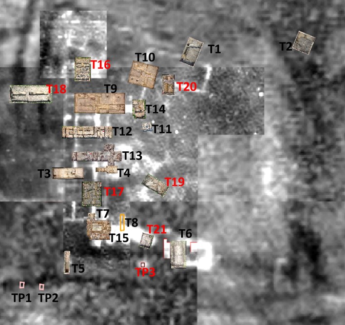
In 2024 we again concentrated on the villa complex and the position of the 2024 trenches (nos 11,12,13,14 and 15) and our earlier trenches in relation to each other and to our resistivity survey are shown right.


Trench 11 (left), started in 2023, was reopened and the feature was confirmed to be a well which appeared to have been deliberately backfilled and capped off. The well was stone-lined to a depth of just under a metre and the cavity was filled with limestone pieces (originally upper structure which had been pushed in prior to capping). There were no signs of long-term use prior to closure. The fill contained few finds and a single coin was found within the backfill nestled against the lining (a copy of a radiate of Tetricus AD 275-285). Perhaps deliberately placed as a votive offering when the well was backfilled?
The objective of Trench 14 (right) was to uncover the SE corner of the aisled building to have a further look at its structure and its relationship with the other buildings. Excavation revealed an east-west wall forming a southern wall to the aisled building. Immediately abutting this wall to the south was a second east-west wall of very robust construction, well finished on both external faces with large edging stones. The inner wall had an integrated turn to the north. All the walls were deeply cut into the natural clay.
The double wall arrangement mirrors that found in Trench 9 and the implication is that the outer wall of the aisled building was reconstructed when the corridored building was built, although that does not fully explain why such a substantial structure was thought necessary (particularly when compared with other walls).

The outer wall does not turn the corner (which would have been the weakest point to protect) as one might have expected if the principal purpose of the double wall arrangement was to support an upper storey or to buttress structural problems (of which we found no evidence).
Trenches 12 and 13 were positioned to examine the central area of the corridored building, which the resistivity survey suggested to be the likely location of principal rooms. Trench 12 (below) uncovered the western and eastern external villa walls and the southern part of a large room with an internal measurement of 5m x 4.4m.

Trench 13 (below) was more complicated. In the western part of the trench, there were two inner walls forming the eastern and western extent of a room with an internal measurement of 5.1m x 5.5m. To the east there were traces of two walls which appear to have been deliberately reduced or removed and replaced by a new outer wall, indicating phased reconstruction, the end-product of which seems to have been the creation of an enlarged room in the front of the villa.

The rooms in these two trenches were separated by an entrance and hallway. As elsewhere on the site, the archaeology is relatively close to the current surface and has been heavily robbed or destroyed by post-Roman agricultural activity. Unfortunately, this means that floor surfaces have disappeared, and we are left with a thin ‘sandwich fill’ of surviving archaeology lying between the subsoil and the natural clay. In some instances, this causes difficulties of interpretation and sequence.
In both trenches (and in Trench 3) there were several red sandstone groups. It is not clear what these are, but the current suggestion is that they are the bottom of post pads. The irregular spacing makes it unlikely that they represent an earlier or later building.
The purpose of Trench 15 was to investigate whether resistivity features to the south of the corridored building were indicative of a southern wing to the villa complex and, if so, whether the wing might be a bathhouse.
The trench (right) revealed the very disturbed remnants of walls and construction trenches for the four walls forming a room or possibly atrium. There were no surviving floor surfaces, and the central area was reduced to the natural clay. There was no evidence as to whether this area was conjoined with the rear of the corridored building.
The eastern wall of thsi room extended to the east to reveal a partially excavated continuation suggesting that there was indeed a southern wing.

The southern wall of the room was found to have a second wall immediately abutting it which appeared to relate to a further room or building to the south.
Remains of rendering between the two walls indicated that the southern wall of was originally an external wall against which the wall of a further room been constructed. There were also indications that there may have been a further room or building in the south-east corner of the trench with an entryway between it and the other southern room. Some opus signinum was found in Trench 15 – far too little to be taken as proof of a bathhouse, but it is noticed that these are the only examples of this type of mortar so far recorded on the site. There were also patches of limescale in the southern wall of the central room, indicative of running water. The trench also uncovered noticeable quantities of ceramic floor tiles, flue tiles and painted plaster fragments– particularly when compared with quantities found in other trenches – but unfortunately none in situ.
- An annual Summary Report on the fieldwork undertaken at Smokedown in 2024 is available to members on the Smokedown Project Reports and Documents page.
2025
Magnetometry survey
In 2025 we were able to complete the magnetometry survey of the southern part of the field to give a complete picture. As can be seen in image (left), there is further evidence of historic field systems as well as ridge and furrow farming both north and south of the central ring ditches within which we have been excavating the villa buildings.
Excavations
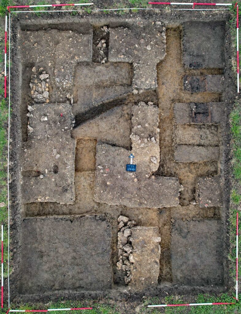
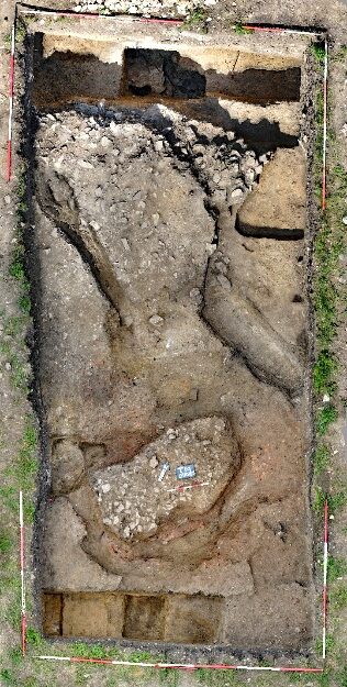
Favourable weather over SOAG’s fifth year of excavation enabled the completion of 6 trenches, each positioned to look at a particular aspect of the site. The positions of T16 to T21 are shown in the picture – right.
Trench 16 – The Aisled Building
Trench 16 was positioned to investigate the northern wall and area of the Aisled Building close to its north-west corner.
Substantial remnants of the northern wall of the west-east orientated Aisled Building were found. The wall proved to be a single structure substantially constructed with unmortared limestone pieces, unlike the double wall arrangement constructed in the south-east corner of the Aisled Building and uncovered in Trenches 9 and 14. A section excavated through the wall width revealed a Samian sherd embedded in the wall construction, suggesting that the Aisled Building was not the first Romano-British building on the site.
There was a substantial scatter layer comprised of limestone pieces, CBM, pottery sherds and limestone roof tiles over the top of the eastern part of the excavated wall and to its south which appeared to be roof and wall tumble from the collapse of the northern end of the Aisled Building.
Limestone roof tiles, one of which still held the nail which would have been used to attach it to the roof battens, in the tumble suggests that the Aisled Building had a limestone tiled roof.
The two westerly post-holes of the northern sequence of six aligned parallel to the wall were uncovered, both having a diameter of 30 cm and a depth of 80 cm. Both post-holes were covered by limestone scatters extending northwards, but they did not appear to have been capped in the same manner as the post-holes in the southern sequence uncovered in Trench 9 – this suggests that whist the southern end of the Aisled Building was incorporated within the Corridored Building, the northern side was left abandoned. A secondary post-hole was cut through one of the clay-lined features referred to below, confirming it was a later addition. This mirrors a similar arrangement at the easternmost post-hole in the northern sequence found in Trench 10 where the main post-hole was supplemented by a smaller one. It appears that these secondary post-holes were remedial work providing additional support for a failing roof.
Trench 16 revealed several areas of burning. There were three clay lined features lying between the two post-holes which appear to be ovens. One oven is significantly larger than the others, with a much greater build-up of charcoal, and it contained bone fragments and a large bone at its base. This oven appears to have fallen out of use and was cut by the secondary post-hole mentioned above. The other two smaller ovens to the south may therefore have been replacements.
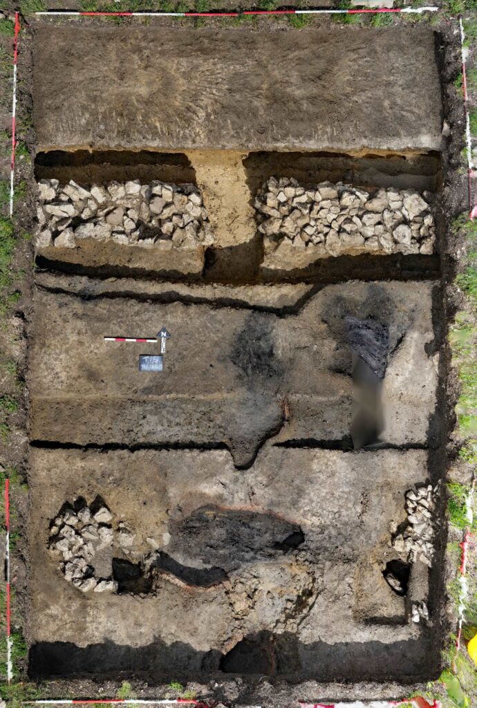
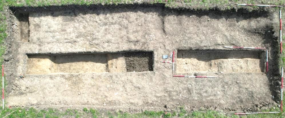
Trench 20 – The Northern Single Span Building
Trench 20 was positioned to investigate the southern wall of the northern Single Span Building which is aligned with the northern inner perimeter ditch of the Late Iron Age enclosure. Trench 20 as excavated is shown in the image below.
The wall was found to have been substantially robbed, leaving only an insubstantial base, approximately 90 cm wide, in the anticipated position. The trench also revealed a series of earlier gullies, as well as a substantial ditch.
The earliest gully runs in a north-easterly direction from the south-west corner of the trench. This was cut by a narrower, slightly deeper gully, following a similar alignment. Both these gullies were in turn cut by a curving gully Whilst the excavated length of the curved gully was too short to permit a definitive view, it is worth noting that if it is indeed circular, it would have had a diameter of around 6 metres and so could be a candidate for a ring gully for a round house.
The earlier gullies are cut by a very substantial north-south orientated ditch approximately 1m wide and 60cm deep, cut as a broad V-shape with a narrow flat bottom 20cm wide. The ditch had a primary silty clay fill and a more mixed upper fill containing charcoal and mortar lenses, as well as a significant amount of fragmented pottery. The pottery has been provisionally dated to the late 1st/early 2nd century AD, consistent with similar dating for pottery previously found under the northern wall of this building in Trench 1.
Trench 17 – The Corridored Building (Villa)
The objective of this trench was to look at the southern part of the Corridored Building in the area between Trenches 3 and 15. The trench revealed a small room or alcove believed from the uneven construction of the eastern main wall to have been accessed from the eastern corridor. The southern and western walls of this room) had a double width (being 1-1.3 m wide in aggregate). There is no obvious explanation for this, but it does suggest that the room may have been formed by a renovation of the original layout. The room’s dimensions (1 x 1.2m) weigh against its use as a living area, so perhaps it was a storage area or housed the family shrine.
An west-east wall was found to cross the eastern corridor – other than for the end walls, this is the only occasion along the length of the corridor where this has been found to occur. To the south of the junction of the eastern main wall with this west-east wall, it was notable that the continuation of the former was less well constructed than the same wall to the north of the junction and contained pieces of painted plaster in its fabric. It also appeared to be offset to the west.
These factors suggest renovation with reused materials but may also indicate that the west-east wall was originally the end wall of an earlier phase of the Corridored Building, which was later extended to the south, again re-using materials. The differing qualities of the wall constructions in Trench 17 add further evidence that the Corridored Building was subject to phased construction, renovation and extension over its lifetime.
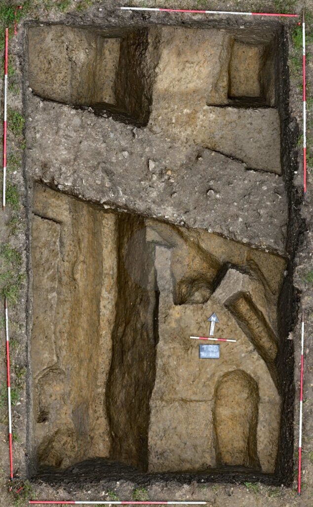
Trench 21 – The Eastern end of the Southern Wing.
This small trench as shown in the picture below was excavated to look at the eastern end of the southern wing of the villa. The evidence is accumulating that the wing was a bathhouse.
Beneath the topsoil there was a very significant amount of rubble, principally CBM including tegulae, imbrexes and bricks. This strongly suggests that the building had a ceramic tiled roof, rather than the limestone roof evident elsewhere in the villa buildings, and a tiled floor. Several large pieces of opus signinum were found across the trench. In the north-eastern area of the trench there was a substantial spread (1.1m E-W and 1.5m N-S) of grey black ash and charcoal approximately 10cm thick which was sandwiched between mortared layers. There was nothing in the ash/charcoal area to indicate whether it was contemporary with the villa, or associated with the destruction of the southern wing, or burning arising from post-occupation activity.
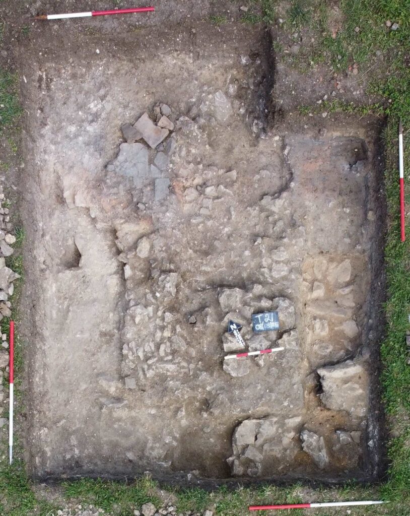
Beneath the lower mortar layer there were two aligned rows of large, faced limestone blocks forming the base of the eastern wall of the southern wing. There were some further laid stones to the west of this wall which might represent the returning southern wall of the wing but this was not conclusive.
Beneath the CBM tumble towards the north-west corner of the trench several pieces of floor tile were found in situ, laid over a base of pink/orange mortar. The top surface of these floor tiles was worn to a darkened patina, possibly the result of being extensively walked upon.
Trench 18 – The late Iron Age enclosure
The purpose of this trench was to look at the western perimeter ditches of the Late Iron Age enclosure. The resistivity survey had shown a double ditch with a possible pit in the area between the two. However, interpretation of the subsequent excavation was rendered difficult by the similarity in colour and consistency of the soils, particularly when exposed to the very hot and sunny weather.
The inner ditch, on the eastern side of the trench, was found to be 3.85m across, which was consistent with the widths of the northern inner ditch in Trench 1 and of the southern inner ditch in Trench 6. Cut into the natural clay: the ditch slopped downwards steeply on its eastern side and more gently on the western side. The fill of silty clay was uniform throughout and contained a scatter of pottery sherds and bone fragments, although not in quantities which would suggest deposits over a long period. These factors suggest that the ditch may have been backfilled as a single event, possibly when the Corridored Building was constructed. The western side of the trench revealed a ditch or pit 1.35m across east-west. The central pit was excavated to a depth of over 1m. Although the fill contained patches of charcoal and a mix of pottery sherds and bone fragments, it did not appear to be the hoped for rubbish pit.
Trench 19 – The Kiln Feature
Trench 19 was intended to investigate resistivity anomalies suggesting structures or features to the east and front of the Corridored Building.
Along the northern end of the trench there was a very deep pit, excavated to a depth of over 1m, with flattish placed stones at the bottom of the excavated depth. The pit was filled with a mixture of yellowish brown and greyish clays with gravel, charcoal, ash, chalk and sand inclusions and also containing fragmented bones, pot and CBM. The pit was covered by a layer of randomly placed unmortared flat stones below a layer of rubble with what appeared to be a compacted surface between the rubble and the subsoil. The feature had the overall appearance of having been backfilled and capped in the Roman period.
The excavation of the southern part of the trench, carried out against the clock at the very end of the session, revealed the remains of a substantial feature appearing to be a dismantled kiln. The kiln was shaped as an inverted cone, but no evidence was found of waste material to indicate its purpose, and as mentioned above there were indications that it was abandoned and covered over in the Roman period.
It is speculated that the feature may have been associated with the making of materials on site for the construction of the Corridored Building. A coin of Valerian (253-260) was found in the subsoil, and this would be compatible with other evidence for a mid-3rd century date for the construction of the Corridored Building.
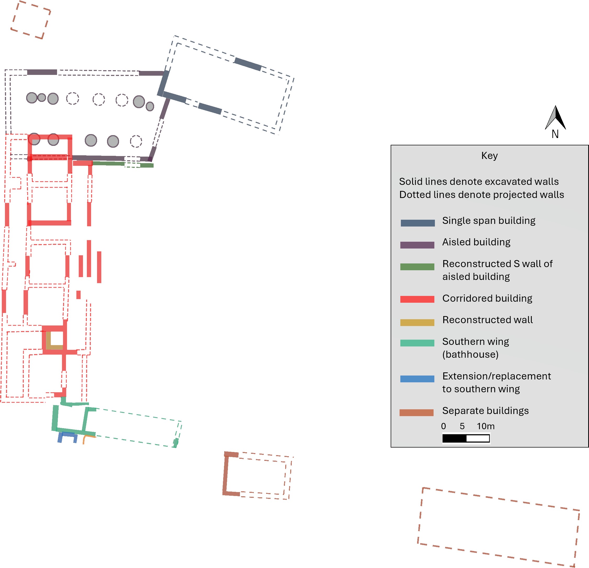
SUMMARY – THE VILLA BUILDINGS
The hot dry weather brought out good cropmarks as shown in the photo (right).
The crop marks show the clear end wall of the southern wing found in Trench 21 and a very straight edge which seems to mark the northern side of the wing – these crop marks are consistent with the resistivity survey.
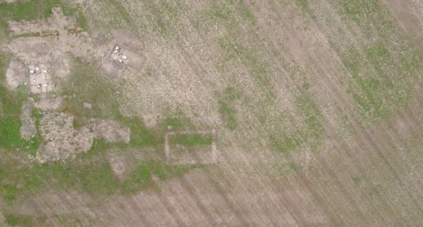
The picture also shows cropmarks delineating the rectangular building constructed over the Late Iron Age enclosure southern inner perimeter ditch and partially excavated in Trench 6, and – further to the east – a further hitherto unknown even larger rectangular building.
The diagram to the right therefore summarises our current understanding of the layout of the villa settlement. (But please note that this diagram does not reflect the phases by which the villa evolved).
- An annual Summary Report on the fieldwork undertaken at Smokedown in 2025 is available to members on the Smokedown Project Reports and Documents page.
As noted above, the full results of the excavations, together with analysis of the finds, are planned to be published in due course in the SOAG Bulletin.